This climb to the central peak of the Alp-like Wallowa Mountains is not for the timid.
About the Hike: Eight valleys radiate from 9,572-foot Eagle Cap, the rock hub of the Wallowa Mountains. Although Eagle Cap is not quite the tallest peak in this range, its 360-degree view is unmatched, and a surprisingly well-graded trail climbs to the summit from the East Lostine River's meadows.
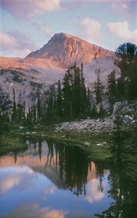
If your goal is the summit, plan on a two-day trip. If you're out for a day hike, settle for a view of the cliff-edged peak from the Lostine meadows or Mirror Lake.
Note that group size is limited to 12 on trails and six in camps. Tents must be at least 100 feet from lake shores, grazing horses must be at least 200 feet from lakes, and campfires are banned within a quarter mile of Mirror Lake.
Difficulty: The 14.8-mile round-trip to Mirror Lake gains 2,020 feet of elevation, so it's a difficult day hike. Plan on a two-day backpack trip if you're headed for Eagle Camp itself - a 19.8-mile route that gains 4,000 feet of elevation.
Season: Open late July through October
Getting There: Drive Interstate 84 to La Grande exit 261 and follow Wallowa Lake signs 55 miles on Highway 82 to Lostine. In the center of town, where the highway turns left, go straight on Lostine River Road, following a pointer for "Lostine River Campgrounds."
This route is a two-lane paved road for the first 12.2 miles to the Lostine Guard Station. Then continue on a rougher, one-lane gravel road another 6.1 miles to road's end at the Two Pan Trailhead.
Fees: A Recreation Fee Pass (Northwest Forest Pass) is required to park here. The pass costs $5 per day or $30 per season.
Hiking Tips: Start at the Two Pan Trailhead. When the trail forks after a few hundred yards, veer left on the East Fork Lostine River Trail. This path climbs steeply for 2.8 miles.
Finally the path levels off beside several ponds at the start of a long, beautiful meadow. Here at last is a grand view ahead to Eagle Cap.
 The trail along the meadow is nearly level for 2.3 miles to a stream crossing at the far end-a possible turnaround point. If you're continuing, hop across the stream at a collapsed bridge. Beyond, the trail climbs 2 miles to a rock cairn at a junction within sight of Mirror Lake.
Detour left to see the lake's reflection of Eagle Cap's snowy cliffs. If you're camping, don't pitch your tent near the fragile lake or the trail, but rather bushwhack up the ridge to the left, where you'll find secluded campsites with great views.
To continue up Eagle Cap from Mirror Lake, return on the main trail to the rock cairn and keep left at all trail junctions. After a mile the trail forks at a signless post. Horton Pass is to the right, but the left-hand path is a shorter, if snowier, route. The two trails rejoin on a ridgecrest and climb left 1.3 miles to Eagle Cap's windswept summit.
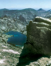
A green ammunition can holds the summit climbers' register. Below you, the Eagle Cap Wilderness spreads out like a colorful map, dotted with blue lakes and striped with green valleys.
History: The Eagle Cap Wilderness was one of the first in the nation, set aside in 1964 when the Wilderness Act was passed.
Geology: During the Ice Age, a glacier from Eagle Cap filled the entire East Lostine Valley, sculpting it into a long U-shaped trough. Look for bedrock that has been rounded and smoothed by the weight of the grinding ice.
By William Sullivan
