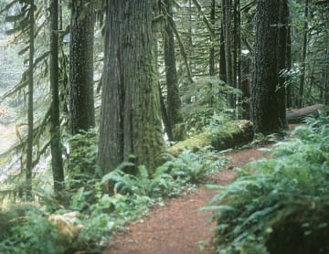
The Old Salmon River Trail provides an easy hike through old-growth forest
About the Hike: A few miles upstream from the Wildwood Recreation Area, this quiet riverside path traverses an old-growth forest with 10-foot-thick red cedars and leads to small sandy beaches with deep green pools suitable for a chilly summer swim. Because a paved road parallels the route, it's easy to arrange a car shuttle so you can hike the 2.6-mile trail one way.
Difficulty: An relatively easy, 5.2-mile hike along the river gains just 100 feet of elevation.
Season: Open all year.
Fees: A Recreation Fee Pass (Northwest Forest Pass) is required to park here. The pass costs $5 per day or $30 per season.
Hiking Tips: From the Old Salmon River Trail parking pullout, the path promptly descends to the river-a clear, 40-foot-wide mountain stream. In this ancient forest, huge Douglas firs filter sunlight for an understory of vine maple, sword fern, shamrock-shaped sourgrass, and deep green moss. Look for "nursery logs," fallen giants that provide a fertile platform above the brush for rows of seedling trees to catch light and take root.
Many side paths lead to the water's edge from the heavily used main trail. After 0.5 mile a particularly noticeable cross-path leads to a beach beside a 10-foot-deep pool in the river. Just upstream from this pleasant picnic site the river tumbles over two four-foot falls.
Continue on the main trail to the 1.3-mile mark. Then watch for another worthwhile side trail to the right. This one crosses a bouldery, mostly dry oxbow slough to a forested island with pebbly river beaches.
Just 250 yards after the side trail to the island, the main trail joins the paved road. Walk along the road's shoulder 200 yards until the riverside trail continues. After another half mile you'll pass the campsites of Green Canyon Campground. Stay on the graveled path past the campground and an adjacent picnic area. Another 0.2 mile beyond, the trail joins the paved road for 200 yards and then ducks back into the woods for 0.2 mile to an upper trailhead parking area at the Salmon River Bridge.
Getting There: From Portland, take Highway 26 toward Mount Hood for 42 miles. At Zigzag turn right at a sign for the Salmon River Road and follow this paved route 2.7 miles. Two hundred yards beyond a National Forest boundary sign, park at a pullout on the right for the Old Salmon River Trail.
History: An Oregon Trail shortcut, the Barlow Road, passed nearby along the Sandy River in pioneer times.
Geology: Mt. Hood has not had a major eruption in written history, but the adjacent Sandy River valley bears testimony to gigantic mudflows and lava flows in the recent geologic past. The Salmon River, in a side canyon, has been largely protected from these changes.
By William Sullivan
