Get a quick introduction to Oregon's roaring rivers, waterfalls, and old-growth forests with a loop trail around the McKenzie River's two grandest waterfalls.
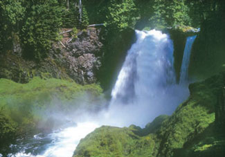
About the Hike: Start at 100-foot-tall Sahalie Falls, a raging cataract that pounds the river into rainbowed mist. Then the route descends past 70-foot Koosah Falls and returns along the river's far shore on the McKenzie River Trail.
Difficulty: An easy, 2.6-mile loop passes Sahalie and Koosah Falls, with 400 feet of elevation gain.
Season: May through November.
Getting There: From Interstate 5 exit 194a in Eugene, drive McKenzie Highway 126 east 68 miles. Beyond McKenzie Bridge 19 miles, near milepost 5, pull into the large, well-marked Sahalie Falls parking area.
Fees: None.
Hiking Tips: From the Sahalie Falls parking lot, walk 100 yards down to the railed viewpoint of the falls. Start the loop by heading left from the viewpoint, following a "Waterfall Trail" pointer downstream. The river churns through continuous whitewater for half a mile before leaping off another cliff at Koosah Falls. Notice the massive springs emerging from the lava cliff near the base of the falls.
 For the loop, keep right at all junctions after Koosah Falls. In another 0.4 mile you'll meet a gravel road beside Carmen Reservoir. Follow the road right 150 yards to a trail sign, take the path into the woods 100 yards, and turn right on the McKenzie River Trail. This route heads upstream past even better viewpoints of Koosah and Sahalie Falls. After 1.3 miles, cross the river on a footbridge and turn right for 0.4 mile to your car.
History: In Chinook jargon, the old trade language of Northwest Indians, sahalie meant "top," "upper," "sky," and "heaven." Sahalie Tyee (heaven chief) was the pioneer missionaries' translation for God. Natives pronounced the word saghalie, accenting the first syllable and using a guttural gh. The word koosah meant "shining" in Chinook.
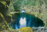
Geology: Over the past 6000 years, half a dozen basalt flows from the High Cascades have tortured the McKenzie River, damming it at Clear Lake, squeezing it into a gorge at Sahalie Falls, and burying it altogether on the dry riverbed near Tamolitch Pool. A hydroelectric project of EWEB, the Eugene Water and Electric Board, has diverted some of the McKenzie River from Carmen Reservoir to Trailbridge Reservoir, making it even less likely for the river to flow above ground for the three-mile stretch above Tamolitch Pool.
By William Sullivan