Location:
From Eugene travel six miles west on Highway 126 to Crow Road. Take Crow Road southwest to its intersection with Territorial Highway. Turn left (south) on Territorial Highway for one mile to Battle Creek Road. Turn right (west) on Battle Creek Road for approximately 100 yards.
Background:
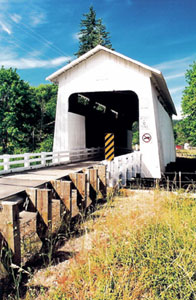
The Coyote Creek Bridge was originally part of Territorial Road (1851) and was included in the state secondary road system. The bridge was bypassed when truck traffic became too heavy and a more direct highway route was constructed.
Heavy snowfall severely damaged the bridge in 1969 as the weight of more than three feet of snow collapsed the entire roof. Chainsaws were used to saw off the rafters, and the bridge remained uncovered until early spring when county crews reroofed the structure.
The Coyote Creek Bridge is often called Battle Creek Bridge because it is located on Battle Creek Road. Others refer to it as the Swing Log Bridge because it was called that many years ago.
County: Lane
Stream: Coyote Creek
Latitude: 43°58'11.3"N
Longitude: 123°19'07.8"W
Truss Type: Howe
Bridge Length (ft): 60
Year Built: 1922
World Guide Number: 37-20-02