The Umpqua River Wild and Scenic Corridor: A National Scenic Byway - From Highway 138 at Highway 97 west to Roseburg.
Your journey through the Umpqua River Basin starts with 10 waterfalls with a variety of picnic areas and hikes. There's something here for all skills and abilities.
Lemolo Falls
Your first stop will be at Lemolo Falls, a 102-foot Horsetail-style waterfall. The word "lemolo" in Chinook language means "wild" or "untamed." The walk to this fall is rated "most difficult" and is 1.7 miles from the trailhead to the top of the falls.
Directions: From Lemolo Lodge - Turn off Highway 138 at mile post 72.8 and follow Road 2610 for 5.2 miles to Lemolo Lodge. Cross over a dam to a fork in the road. Take the left fork, Road 2610-600. Proceed a half mile, turn left across the wooden bridge and park at the trailhead.
Warm Spring Falls
The next waterfall to visit is Warm Spring Falls, a block-type falls that drops more than 70 feet to a pool below. The trail leads to the top of the falls because there is no access to the bottom of the falls. This trail is rated as "easy."
Directions: From mile post 72.8 on Hwy 138 turn north on Road 2610, going approximately 6 miles. After the dam turn left on Road 600, proceeding approximately 3 miles to Road 680. Turn left and proceed 1.7 miles to the beginning of the Warm Springs Trail #1499.
Clearwater Falls
This segment-style fall cascades 30 feet over moss-covered rocks and a tree to a pool below. It is a short walk to from the Clearwater Falls campground on Clearwater Creek. This trail is rated easy.
Directions: At mile post 69.5 on Highway 138: Turn into the Clearwater campground entrance. follow the access road 0.2 miles to the picnic area.
Whitehorse Falls
Whitehorse Falls is located in the Whitehorse Falls Campground. This is a 15-foot punch bowl type waterfall on the Clearwater Creek. The trail is rated easy.
Directions: At mile post 65.9 on Highway 138: Turn in to the Whitehorse campground entrance.
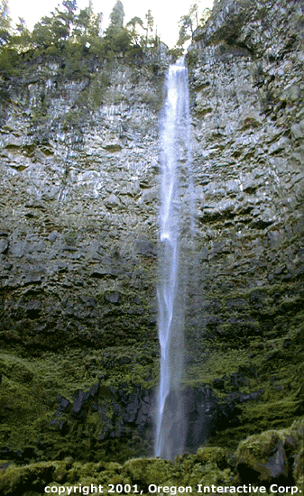
Watson Falls
Watson Falls (photo above) is the highest waterfall in southwest Oregon. This 272-foot plunge-type waterfall roars over a basalt lava cliff and flows to a pool below. A wooden bridge crosses Watson Creek offering an excellent view the falls. The falls arevisible from the parking lot. This trail is rated as difficult but it offers a breathtaking view once you reach the pool.
Directions: At mile post 60.5 on Highway 138, turn on to road 37. The trailhead parking is on the right.
Toketee Falls
The North Umpqua River flows through a narrow gorge creating these falls. The trail to this tiered-type fall takes you through an old growth forest to a sturdy viewing platform across the small gorge. From there you can see the falls cascade over two drops. The first drop totals 40 feet drop, the second flows over an 80-foot shear basalt cliff to a pool below. Toketee is also a Chinook word that means "pretty" or "graceful," an apt name for this inspiring waterfall. This trail is rated as difficult.
Directions: At mile post 58.6 on Highway 138, turn on to Road 34. Cross the first bridge and turn left to the trailhead parking.
Steamboat Falls
These falls are up Steamboat Creek, a very important steelhead-spawning tributary on the North Umpqua River. Steamboat Falls, located at Steamboat Campground, is a 25-foot block-type fall. You can watch Steelhead attempting to jump to the top of the falls from May through October. This trail is rated as easy.
Directions: At mile post 38.8 on Highway 138, turn on to Steamboat Road 38. Drive 5.3 miles to Road 3810, turn right and stay to the left 0.6 miles to Steamboat Falls campground entrance.
Fall Creek Falls
This tiered-type of fall flows over two drops, the first a 35-foot drop to the second 50-foot fall and a pool below. The trail to the falls leads you through a bedrock crevice of basalt and lush vegetation. This trail is rated as difficult.
Directions: At mile post 32.2 on Highway 138. Trailhead parking on the north side of the Highway.
Susan Creek Falls
Stop at the Susan Creek picnic area. There you will find the trailhead leading to Susan Creek Falls, a 50-foot fan-type waterfall covered in lush moss and ferns. This trail also will take you to the Susan Creek Indian mounds. Here young Indian boys approaching manhood would fast and build stone piles and then spend the night in search of a vision from a guarding spirit. This trail is rated as easy to the falls and difficult to the Indian mounds.
Directions: At mile post 28.2 on Highway 138. Parking in picnic area or at the trailhead.
Deadline Falls
Deadline Falls is short but massive. Between May and October, anadromous (sea run) steelhead and salmon may be observed jumping up this powerful fall on their journey from the Pacific Ocean to spawn in the tributary waters of the Cascade Mountains.
Directions: At mile post 22.2 east of Idleyld Park, turn into Swiftwater Park, cross over the bridge and park at the trailhead. This area is the western most end of the 79-mile North Umpqua Trail #1414.
Side trails to Deadline Falls
Watchable wildlife is located on the North Umpqua Trail #1414 that begins at Swiftwater Park by the falls. This trail is 79 miles long and follows the river all the way to the Pacific Crest Trail in the Oregon Cascade Recreation Area.
The trail at Swiftwater Park is accessible to the disabled and is popular with seniors and families with young children. This trail is rated as easy.
Idleyld Park
After a long day of hiking and mountain biking, it may be time to rest and enjoy the small community of Idleyld Park. Here you find food, lodging and river guides to help you experience the Umpqua River as it flows into the 100 valleys of the Umpqua Basin.
Glide
The community of Glide the site of the Colliding Rivers, a geologic phenomenon where two rivers collide head on (North Umpqua and Little rivers).
This was once the site of an important Indian fishing village of the Upper Umpqua Indian Tribe. Here they would spear salmon and steelhead to smoke over their fires as an important part of their food supply.
Whistlers Bend County Park and Boat Ramp
Whistlers Bend is a 126-acre park situated on the North Umpqua River where it makes a sweeping bend in the river. You can rent a Yurt, take an RV space or pitch a tent. The campground includes hot showers. Whistlers Bend also has a very popular Frisbee golf course and makes a great location for family reunions and company picnics.
Information sources used for this page:
- Bill Blodgett, Oregon Ridge & River Excursions
- Bureau of Land Management / Roseburg office
- U.S. Forest Service Umpqua National Forest
- Roseburg Visitors & Convention Bureau/Colliding Rivers Information Center