Length: 70 miles / 112.0 km
Time to Allow: Allow 3 to 5 hours minimum. However, many travelers take a few days to experience all the sights.
Driving Directions
In order to travel the Byway itself, follow the keystone signs from Troutdale east to Dodson and from Mosier east to The Dalles.
To get to the Byway from Portland, follow Interstate 84 east to the Sandy River in Troutdale. Take exit 18 and travel south along the Sandy River to the Sandy River Bridge. Follow the keystone-shaped signs through Springdale, Corbett, and the waterfall area to the junction with Interstate 84. Continue east on Interstate 84 to Mosier (exit 69). Follow the keystone signs through Mosier to Rowena Crest, and then to Chenoweth Creek, located just west of The Dalles.
- Please note that the eastern part of the Byway is US 30, but the western part is not.
Description
Words fail many travelers who drive the exquisite Historic Columbia River Highway. Every twist and turn brings a new treasure, from majestic waterfalls, including Multnomah Falls, the most visited natural site in Oregon, to astounding views from the tops of cliffs over 900 feet above the river. During the spring, the Gorge area erupts into magnificent wildflower displays, including many plants that only exist in this area.
This is the first scenic highway in the US to gain the distinction of National Historic Landmark. Just to give you an idea of what this means, less than 3 percent of the sites on the National Register of Historic Places become Landmarks. The construction of this Highway was considered one of the greatest engineering feats of the modern age. Its engineer, Samuel C. Lancaster, did not [want] to mar what God had put there. It was designed in 1913 to take advantage of the many waterfalls and other "beauty spots."
Make sure you travel both the well-known western section of the Byway from Troutdale to Dodson, as well as the less-traveled eastern section from Mosier to The Dalles. The difference in vegetation zones and views between the two sections will amaze you!
Points of Interest
Multnomah Falls, the second highest year-round waterfall in the United States, is two-tiered and drops 620 feet. A steep paved trail leads visitors to a platform above the falls. The waterfall is visually complimented by Benson bridge, built in 1914 by local contractor Robert R. Ringer, and Multnomah Falls Lodge built in 1925. Inside the Lodge is a gift shop, restaurant and US Forest Service Information Center.
Bonneville Lock and Dam connects Washington and Oregon and is a National Historic Landmark. There are two visitors centers. The one accessed from exit 40 on Interstate 84 highlights history of the dam and the fish ladder.
The one accessed from Washington State Route 14 concentrates on electricity generation, with a trip down into a giant turbine. The Oregon side also includes a fish hatchery with views of salmon and sturgeon.
It takes more than 100 people to operate and maintain Bonneville Lock and Dam each year. The work force includes engineers, powerhouse and lock operators, office administrators, skilled laborers, warehouse workers, biologists and park rangers.
 Historic Columbia River Highway State Trail - This Millennium Legacy Trail is based on sections of the Highway that were abandoned with construction of Bonneville Dam in 1936 and the later (1950s) construction of the "water grade route" now known as Interstate 84.
The first section, between Tanner Creek and Eagle Creek, was restored and re-opened in 1996. This included restoration of the Toothrock Viaduct, the Eagle Creek Viaduct, a new bridge over the Toothrock Tunnel, and a new stairway.
The Eagle Creek to Cascade Locks section was restored in 1998. This section included restoration of the Ruckel Creek Bridge, construction of several rockery walls and construction of a new undercrossing of Interstate 84. It also included construction of trailheads at Eagle Creek and under the Bridge of the Gods in Cascade Locks.
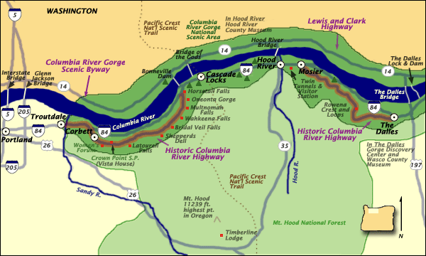
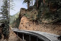
The Hood River to Mosier section has been under restoration since 1995. The Mosier Twin Tunnels were opened in 1996. Trailheads were constructed at both ends.
 The Senator Mark O. Hatfield West Trailhead was constructed in an old gravel pit, restoring it with native vegetation. The Twin Tunnels Visitor Station opened on Memorial Day weekend in 2000. The Rockfall Catchment was complete in June 2000. This structure extends 700-feet west of the west portal of the Mosier Twin Tunnels. It is required to make the area safe from falling rock.
The area is open to hikers and bikers. It is a challenging 4.6-mile route for wheelchair users. Antique cars will be allowed 2-5 times a year under special permit. The Dedication occurred in July 2000, with a run/walk in the morning.
The Moffett Creek to Tanner Creek section was completed in 2000, lengthening the western section of the HCRH State Trail to 5.2 miles. This section restored the Moffett Creek Bridge, the longest, three-hinged, concrete flat arch bridge in the country when it was completed in 1915.
In November 2001 the Starvation Creek to Viento section was upgraded to be ADA accessible at the Starvation Creek end. This includes improving accessibility to view the Starvation Creek waterfall. This one-mile section connects two Oregon State Parks.
Camping is available at Viento. Design and construction has been under the direction of the Oregon Department of Transportation. The HCRH State Trail will be operated and maintained by Oregon Parks and Recreation Department. Other partners include the HCRH Advisory Committee, Federal Highway Administration, Friends of the Columbia Gorge, Columbia River Gorge Commission and the Columbia River Gorge National Scenic Area, USDA Forest Service.
Bridal Veil Falls are worth the short, verdant walk from the car. The trail to the falls will also take you, shortly, to an overlook of the river.
Bridge of the Gods as it exists today was created in a much less glamorous fashion than the original, natural one. It was built by man, by hand, and with difficulty. Constructed in 1926, the Bridge of the Gods is the third oldest bridge on the Columbia River. It plays a major role in the Pacific Crest Trail by linking Oregon and Washington states.
Revenues from the bridge pay for maintenance, painting and inspections along with repayment of the bonds that built the bridge. While the cost to build the bridge was $602,077.58, it could cost around $13 million to replace the bridge as it stands today.
The original, natural bridge was constructed in a much grander way. Indian legend says the Great Spirit built a bridge of stone that was a gift of great magnitude. Scientists say that about 1,000 years ago the mountain on the Washington side of the Columbia river (near what is now the town of Cascade Locks,) caved off, blocking the river.
The natural dam was high enough to cause a great inland sea covering the inland prairies as far away as Idaho. For many years, natural erosion slowly weakened the dam and finally washed it out. The waters of the inland sea rushed out, tearing away more of the earth and rock until a great tunnel was formed under the mountain range, leaving a natural bridge over the water. The bridge was called "The Great Cross Over" and is now named "The Bridge of the Gods."