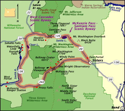
Length: 82 miles / 131.2 km
Time to Allow: Allow 3 to 5 hours, including time to stop at overlooks.
Fees: Parking passes can be purchased from the ranger station, allowing you to park and hike the trails along this Byway.
Driving Directions
There are several ways to get to the Byway:
From Bend: Take US Highway 20 west to the town of Sisters.
From Sisters: Head west on State Highway 242 to the edge of town where the Byway begins. The Byway's East Portal is located here.
From Eugene: Take State Highway 126 east to the McKenzie Ranger Station (the site of the Byway's West Portal information facility), and then go to the junction of State Highways 126 and 242 where the Byway begins
Description
Discover the highest concentration of snowcapped volcanoes (and associated glaciers) in the lower 48 states when you drive the the McKenzie Pass-Santiam Pass Scenic Byway! Enjoy the breathtaking sight of Broken Top Mountain and the Three Sisters, along with their waterfalls, towering gloriously above the route.
Ancient lava fields lying next to calm, clear lakes, will provide you with a gentle reminder of the area's violent beginning. This area really illustrates how the Cascade Range was built.
Points of Interest
Belknap Viewpoint - From this viewpoint, you can see the Belknap Crater Complex, clear evidence of "recent" volcanic activity. The Belknap Crater Complex, a broad shield five miles in diameter and about 1,700 feet thick, was formed by fields of lava vents that erupted profusely about 1,500 years ago.
The exception in this Complex to that particular activity is Little Belknap: it erupted about 1,500 years earlier than that (about 3,000 years ago.) When Little Belknap was formed, lava poured 12 miles to the west and ash was ejected from the northernmost of the two summit craters.
Dee Wright Observatory among the basaltic lava fields. The Dee Wright Observatory, a stone memorial named for the CCC foreman who oversaw its construction, offers panoramic views of the Cascade Mountain Range, as far north as Mt. Hood.
A bronze peak-finder in the observatory points to the geologic features in the sweeping lava fields where the observatory is situated. A barrier-free access trail takes visitors to an interpretive platform, which offers information on the history of the structure built in the 1930s by the Civilian Conservation Corps.
A half-mile interpretive trail takes visitors on a 30-minute walk through lava flows and offers spectacular vistas of the surrounding landscape.
Deschutes National Forest is a recreational haven, pure and simple: these 1.8 million acres include five wilderness areas (200,000 acres,) six cool rivers, 157 lakes and reservoirs, approximately 1,400 miles of trails, and the unique landscape of Newberry National Volcanic Monument.
Popular activities in the national forest include hiking, fishing, rafting, mountain biking, kayaking, canoeing and camping. Cross-country skiing and snowmobiling are popular in the winter when the road closes due to snow.