Attractions

Kla-Mo-Ya Casino

You’ll feel at home at Kla-Mo-Ya Casino where the staff are friendly and the atmosphere is buzzing. Offering not only slots and table games, but weekly promotions and exciting giveaways, what are you waiting for?

34333 Hwy. 97 North
Chiloquin, OR 97624

1-888-552-6692

Map/Directions


Tags:
City:
Region:

L & S Gardens

A  2 ½ acre garden store that features greenhouses, antiques, tips and a wide arrange of gardening tools and supplies. They even deliver dirt, gravel and barkdust to local customers, but for those out of town visitors, you can find unique gifts and plants that will thrive in just about any North American climate. 

La Pine State Recreational Area

If you want to immerse yourself in a subalpine pine forest where the air has that high-Cascades tang; to stay in a clean, quiet campground next to a twisting, cold river brimming with trout (and a nearby legendary fly fishing spot) and surrounded by miles of waiting-to-be-explored wilderness; to sit smack in the middle of dozens of high-mountain lakes (in winter, near some of the best ski-spots in the land); to see eagles or red-tailed hawks grabbing breakfast right in front of you; or, to just sit in a campsite pondering what you might do tomorrow ...

Lake Creek (Nelson Mountain) Covered Bridge

Location:
From Eugene take Highway 99 north to Highway 36. Travel west on Highway 36 approximately 38 miles to Nelson Mountain Road. Alternately, travel north from Mapleton on Highway 36. The Nelson Mountain Road turnoff is located near milepost 17. Turn south on Nelson Mountain Road to the bridge.

Background:
The Lake Creek Bridge, or Nelson Creek Bridge as some call it, was built in 1928 for the modest price of $3,155.

Lava Land Visitor Center

Come discover how our local geology, ecology, climate, and culture are all interwoven at the Lava Lands Visitor Center. The latest information on various topics including volcanic activity in the Cascade Mountains and Paleo-Indian technology is available and hands on activities will delight both young and old.

Lava River Cave

Explore a mile-long lava tube. Lava River Cave offers self-guided exploration of a mile-long lava tube. It takes approximately 1.5 hours to tour the entire cave. Initial access descends 150 stairs to an uneven floor and can be challenging. In the interest of preventing the spread of White-nose Syndrome to bats that reside in the Cave, we ask that you not wear or bring into the cave any clothing or gear you have used in a cave or mine outside of Oregon or Washington. Please wear close-toed shoes and warm clothing. Average temperature in the Cave is 42 degrees Farenheit.

Lawrence Gallery

If you love the beauty and wonder you can find at the Oregon coast, there is a spot, in between Lincoln City and Newport, where there is beauty you can take home.

The Lawrence Gallery has hundreds of examples of awe-inspiring artwork that will add that spark to any business office, living room or entry way. The gallery shows many different media including bronze sculptures, paintings and wall-hangings. Styles range from metalwork, to ceramic, to oils and pastels.

Lillie Belle Farms

The chocolate store, located on Highway 99, or North Front Street in Central Point, opened its current location a few years ago to take advantage of what business owners in the area call an “artisan grouping.” Lillie Belle is located next to Rogue Creamery (who built the building for him) and it has big windows where you can watch Shepherd make his confections.

Little Butte Creek (Antelope Creek) Covered Bridge

Location:
From Highway 62 in Eagle Point, turn east onto Linn Road (sign points to Eagle Point and Klamath Falls). Travel to South Buchanan Street and turn left. Turn right onto West Main Street and continue to Royal Avenue. The bridge is located in the city of Eagle Point at the intersection of Main Street and Royal Avenue.

Background:
The bridge originally spanned Antelope Creek some 10 miles southeast of Eagle Point. In August 1987, the structure was loaded onto a makeshift trailer and volunteers hauled it to the city of Eagle Point.

Little Mexico in Woodburn

Mexican flavor, north of the border

By Vicente Guzman-Orozco
For Oregon.com

Sometimes you just feel like leaving behind the drudgery of work, closing those books and fleeing the office for mañana-land, eating some ceviche and washing it down with a cold cerveza. And you know all it takes is a drive south.

It is not as far as you may think; you can get a taste of old Mexico just 30 miles south of Portland, Oregon. Woodburn, an unassuming town in the heart of Marion County, offers the charms of south of the border without venturing far from the metropolitan area.

Little River (Cavitt Creek) Covered Bridge

Location:
From Roseburg take Highway 138 east to Glide. Just before entering Glide turn south on Little River Road. The bridge is approximately seven miles south of Highway 138 at the intersection of Little River Road and Cavitt Creek Road (county roads 17 and 82).

Background:
The Cavitt Creek Bridge, crossing Little River at the junction with Cavitt Creek, is another of the wooden structures built by Floyd Frear, noted Douglas County builder.

Lonesome Hickory (Carya ovata)

Mary Louisa Black planted this shagbark hickory near her home in 1866 from nuts she carried from Missouri on the Oregon Trail in 1865. Of the nuts she planted, two grew into trees, This tree is the lone survivor of snow, summer heat and Rogue River flooding and the only shagbark hickory in the area.

It is located in Jackson County, one mile south of Shady Cove, Oregon next to Highway 62.

Approximate Height: 18'
Circumference: 4'
Age: 131 years
Dedicated: April 6, 1998

Lost Creek (Parvin) Covered Bridge

Location:
From I-5 take Highway 58 east to Dexter, just west of Lowell. Turn south on Lost Creek Road. Turn right onto Rattlesnake Road from Lost Creek Road at Mile Point 1.8, and follow Rattlesnake west for 0.5 miles. Turn south on Lost Valley Lane to Parvin Road. Alternately, exit Highway 58 at Lost Creek Road and travel southeast to Parvin Road. Continue south on Parvin Road to the bridge.

Lost Creek Covered Bridge

Location:
From Eagle Point, continue southeast on Royal Avenue to Highway 140. Alternately, travel east on Highway 140 from Highway 62, Crater Lake Highway. Continue on Highway 140 to Lake Creek Loop Road. From Lake Creek Loop Road, travel south through Lake Creek on South Fork Little Butte Creek Road. Turn south on Lost Creek Road and continue approximately one half mile. Lost Creek Bridge is 4 miles south of Lake Creek.

Lowell Covered Bridge

The Lowell Covered Bridge is a bridge crossing the Willamette River outside of Lowell, Oregon. The original bridge was built in 1907 and it was rebuilt in 1945, and rehabilitated in 2006. It currently is a self-guided interpretive center that gives visitors the history of covered bridges in Oregon. The bridge is 165 feet long and clears the water by two feet.

Magness Memorial Tree Farm

Some of the best times in my childhood were spent running around exploring Magness Memorial Tree Farm.

The tree farm, operated by the World Forestry Center, is an 80-acre marvel of quintessential Oregon outdoors. It has 2.5 miles of hiking trails that are well maintained, and some are even paved. It’s a safe place to explore the Oregon outdoor, without fear of getting lost in some wilderness, as all trails are very well marked.

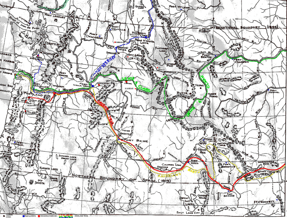
Maps of the Oregon Trail


On the trail to Oregon:

  • A map of trails, missions, trading posts and forts
  • Missouri River and the American Fur Trade: A Map of Early Forts and Posts
  • Map of the Wind River Region

A map of trails, missions, trading posts and forts


Missouri River and the American Fur Trade: A Map of Early Forts and Posts

Marys River (Harris) Covered Bridge

Location:
From Corvallis take Highway 20 through Philomath to Wren. Exit the highway, turn right twice to head back under the highway (veering) to the right at the "Y". Continue to travel west on Harris Road for approximately 2.5 miles.

Background:
The Harris Bridge was built by H. W. Fiedler to replace a covered bridge at the same site. Although Benton County records show 1936 as the construction date, some locals claim the span may have been built in 1929.

McKenzie Pass-Santiam Pass Scenic Byway

Discover the highest concentration of snowcapped volcanoes (and associated glaciers) in the lower 48 states when you drive the the McKenzie Pass-Santiam Pass Scenic Byway! Enjoy the breathtaking sight of Broken Top Mountain and the Three Sisters, along with their waterfalls, towering gloriously above the route.

McKenzie River (Belknap) Covered Bridge

Location:
From Springfield take Highway 126 east approximately 46 miles to the community of McKenzie Bridge. One mile west of the small town of Rainbow, turn south on McKenzie River Drive. Follow McKenzie River Drive for about 0.8 miles to King Road West.

Background:
The Belknap Bridge occupies a site in which a covered bridge has been in continuous use since 1890. The neighboring community recognized the importance of a river crossing at that location and adopted the name "McKenzie Bridge."