A slot-like chasm with waterfalls
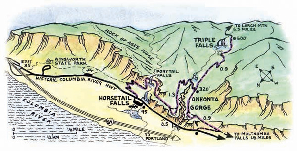
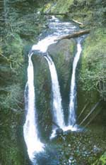
About the Hike: Next door to busy Multnomah Falls but usually overlooked by tourists, this delightful trail explores a cavern behind Ponytail Falls and then loops around Oneonta Gorge, a mossy chasm so narrow that Oneonta Creek fills it wall to wall. An optional 1.8-mile side trip leads to Triple Falls, where three plumes of water plunge 120 feet at once.
Difficulty: The easy 2.7-mile loop around the gorge gains just 400 feet of elevation. An optional side trip to Triple Falls adds 1.8 miles of distance and 300 feet of elevation.
Season: Open all year.
Getting There: Drive Interstate 84 east of Portland 35 miles to Ainsworth Park exit 35 and follow the old scenic highway 1.5 miles back to the large Horsetail Falls Trailhead parking area.
Fees: None.
Hiking Tips: The trail starts from the historic Columbia River Highway beside 176-foot Horsetail Falls and climbs along a mossy slope of little licorice ferns. In late spring tiny white candyflowers and pink geraniums crowd the path.
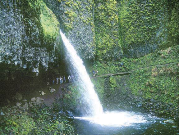
 After 0.2 mile turn right on the Gorge Trail, which soon ducks behind 80-foot Ponytail Falls (alias Upper Horsetail Falls). The lava flow that created this falls' stony lip also buried a layer of soft soil. The falls have washed out the underlying soil, creating the cavern.
Beyond Ponytail Falls 0.4 mile take a right-hand fork for a quick viewpoint loop out to a cliff edge high above the highway. The view extends up the Columbia to Beacon Rock, but keep children away from the unfenced edge. Then continue on the main trail another 0.4 mile, switchback down to a dramatic metal footbridge above 60-foot Oneonta Falls, and climb to a junction with the Oneonta Trail.
Turn left here if you'd like to take the optional side trip up to Triple Falls and the perfect spot for lunch: a footbridge in a scenic creekside glen at the top of the falls. Otherwise continue the loop by turning right on the Oneonta Trail for another 0.9 mile and turning right along the road to the mouth of slot-like Oneonta Gorge. With any luck you'll be able to rest on the creek's pebble beach here while one of your party runs up the road another 0.3 mile to fetch the car.
The best way to see the inside of Oneonta Gorge is to put on sneakers and wade knee-deep up the creek from the highway bridge. In late summer when the water's not too deep nor too cold, it's usually possible to trek half a mile through the 20-foot-wide chasm to an otherwise hidden, 100-foot falls. This adventure is not for the faint of heart, however, because the route sometimes involves clambering over a logjam or wading a chest-deep pool.
History: Originally, the old Columbia Gorge Highway crossed Oneonta Creek and bored through the neighboring cliff in a tunnel. From the highway bridge at the mouth of the gorge,look for the old tunnel entrance on the cliff to the left, now filled with rubble.
Geology: Oneonta Creek has cut down through a series of Columbia River Basalt lava layers by following a fault line - a crack in the ground that aligns this gorge as straight as an arrow.
By William Sullivan