Step away from the established overlook, walk into the sand and discover Oregon's seaside Sahara.
About the Hike: Visitors who simply photograph the view from the Oregon Dunes Overlook are missing the best scenery in this seafront Sahara. It's just over a mile from the overlook's picnic area to a remote, windswept beach. Even better is a 4.8-mile loop hike to beautiful Tahkenitch Creek, through dunes and tree islands.
Difficulty: An easy, early level 1.1-mile route through the sand leads to the ocean. For a moderate, 4.8-mile loop, continue to Tahkenitch Creek. Some route-finding skills are required, because the route through the sand is marked only by infrequent posts.
Season: Open all year.
Getting There: Drive Highway 101 south of Florence 10 miles (or north of Reedsport 11 miles) to a turnoff between mileposts 200 and 201.
Fees: Expect a $5 parking fee.
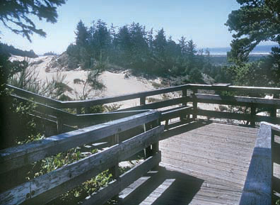
Hiking Tips: From the parking area's turnaround, take a paved path to the right. This trail switchbacks 0.3 mile down through the forest into the dunes themselves.
 Once in the open sand, head toward the roar of the ocean, first following posts in the dunes and then a trail across the deflation plain. Crest the foredune and head left along a remote, windswept stretch of beach. Seals peer from the surf. Pipers and gulls run along the waves' edge. Shells of razor clams, scallops and sand dollars litter the beach.
After 1.7 miles, turn inland at a brown hiker-symbol sign atop the foredune. This path touches a bend of lazy Tahkenitch Creek, curves left across a willow marsh full of driftwood, and climbs around the edge of a tree island. After another view of Tahkenitch Creek the trail vanishes into open dunes. Head straight across the sand to find posts marking the route along the left side of two more tree islands back to your car.
History: Man changed the dunes' ecology by introducing European beachgrass to stabilize sand near railroads in 1910. The stubborn grass spread along the beach, creating a 30-foot-tall foredune. Because this grassy dike stops sand from blowing off the beach, the inland dunes have been cut off from their supply of sand.
The last dunes still marching eastward are expected to disappear within a century. Already they have left behind a broad deflation plain, a marshy area regrowing with brush and trees, between the ocean and the dying dunes
Geology: Along most of the Oregon Coast, bluffs block the prevailing west winds from blowing beach sand inland. But in the lowlands of the Oregon Dunes, wave after wave of wind-driven dunes have marched ashore. Each onslaught buries forests before gradually petering out and sprouting forests of its own.
By William Sullivan
