
Location:
Regions: Southern Oregon
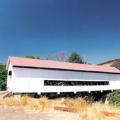
Location:
From Canyonville travel east on Third Street and continue through Days Creek to the community of Milo. The bridge is located east of Milo at Milepost 20.5
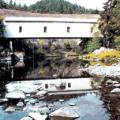
Location:
Exit Interstate 5 at Myrtle Creek. Follow Highway 99, the main street through downtown. The bridge is to the west in Mill Site Park.

Terrain: 6,464-foot top elevation, 764-foot vertical drop
Lifts: one triple, one surface
Nordic: 1.5-mile of groomed trails
City: Lakeview

P.O. Box 220 | Ashland, OR | 541.482.2897
Terrain: Top Elevation 7,500
Lifts: Six chairlifts: 2 triples, 2 doubles, 1 surface, 1 learning
City: Ashland

You’ll feel at home at Kla-Mo-Ya Casino where the staff are friendly and the atmosphere is buzzing. Offering not only slots and table games, but weekly promotions and exciting giveaways, what are you waiting for?
City: Chiloquin
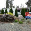
Our beautiful RV Resort has so much to offer, from the beautiful scenery to natural attractions such as the Oregon Caves National Monument and California Redwoods.
City: Grants Pass
On September 13, 1888, after traveling two months along the spine of the Cascade Range, Judge John B.
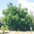
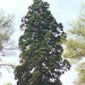
Mary Louisa Black planted this shagbark hickory near her home in 1866 from nuts she carried from Missouri on the Oregon Trail in 1865.