Covered Bridges

Covered Bridges of Oregon

What is a "World Guide Number?"

Local naming of covered bridges can prove to be inconsistent, and many bridges have more than one name.

Each bridge in this section has a unique identification called a World Guide Number. This system of identifying covered bridges on a national scale was developed in the 1950s and has been adopted by the National Society for the Preservation of Covered Bridges.

The assigned World Guide Number for each bridge is the combination of a state, county and bridge identifier.

Oregon, being the 37th state alphabetically, dictates the first two digits of the identifier.

The counties are also assigned numbers in alphabetical order. All bridges in Benton County, for example, contain the number 37-02- because Benton County is the second county in the state alphabetically.

The third set of numbers are assigned to the actual bridge location, although the name of the bridge or stream is not a factor in the assignment. Many bridges have been destroyed since the adoption of the World Guide Number. Since the number is not reused or reassigned, some numbers are missing.

Combinations of numbers and letters denote a bridge which does not use a true truss for support but is covered nonetheless.

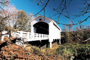
Earnest Covered Bridge
Earnest Bridge over the Mohawk River in Lane County is World Guide No. 37-20-35

Information included in this section was provided by Bill Cockrell, who with his brother Nick authored "Roofs Over Rivers" and is presented here in cooperation with the Covered Bridge Society of Oregon.

North Fork of the Middle Fork Willamette River (Office) Covered Bridge

Location:
From Interstate 5 take Highway 58 east towards Oakridge. Just before entering Oakridge, near milepost 31, turn west onto Westridge Ave. Continue to Westfir on County Road 6128. Travel about 2.5 miles to the mill site, community and bridge.

Background:
The Office Covered Bridge was built in 1944 by the Westfir Lumber Company and spans the North Fork of the Middle Fork of the Willamette River, once the site of a mill pond at the town of Westfir.

North Fork Yachats Covered Bridge

Location:
From Yachats travel approximately 7 miles east on Yachats River Road to N Yachats River Road. At the intersection turn north and travel approximately 1.5 miles.

Background:
The rustic covered bridge spanning the North Fork of the Yachats cost the county only $1,500 when built in 1938, and was the last covered span constructed by veteran bridge builder Otis Hamer.

City:
Region:

Oak Creek (Irish Bend) Covered Bridge

Location:
Located on the Oregon State University campus in Corvallis. From I-5, exit 234 at Albany, travel southwest on Highway 20 to Corvallis. Follow Highway 34 southwest toward Philomath. Turn right (north) on 53rd Street and park in the County Fairgrounds on the west side of 53rd. Follow the foot path (Campus Way) on the east side of 53rd to the bridge.

Pass Creek Covered Bridge

Location:
From Highway 99 (West B Street) in Drain, turn south onto 2nd Street and go one block to West A Street. Located in the city of Drain, behind Drain Civic Center at 205 W. A Street.

Background:
Although the official date of construction of the current Pass Creek Bridge is listed as 1925, members of the Umpqua Historic Preservation Society attest the span was constructed in 1906.

Ritner Creek Covered Bridge

Location:
From Interstate 5 exit 258 and follow Portland Road 5 miles to the junction of Highway 22 (Marion Street). Turn right (west) crossing the Willamette River, and continue 17 miles to Dallas. From Dallas travel south on Highway 223 approximately 12 miles through Pedee. Ritner Creek Bridge is approximately 3.5 miles south of Pedee.

Background:
Ritner Creek bridge was the last covered bridge on an Oregon state highway.

Row River (Currin) Covered Bridge

Row River (Currin) Covered Bridge Location:
Travel four miles southeast of Cottage Grove on Row River Road to the intersection of Layng Road. The bridge crosses the Row River at this location and is located one mile from the Mosby Creek Bridge, also on Layng Road.

Row River (Dorena) Covered Bridge

Location:
Travel five miles east of Cottage Grove on Row River Road to the junction of Government Road. Continue east on Government Road seven miles to the bridge.

Background:
When Dorena Dam was built in 1946, plans were made to span the Row River at the upper end of the reservoir. Government Road along the west bank was completed in 1949, and the Dorena Bridge was built a year later, after the reservoir was filled, at a cost of $16,547.

Salem Power Canal (Stayton-Jordan) Covered Bridge

Location:
From Interstate 5 take Salem Exit 253 east on Highway 22 for 15 miles to the Stayton /Sublimity turnoff. Travel south one mile to Stayton. Turn east on Marion Street to Pioneer Park.

Background:
Prior to 1986, the Jordan Bridge spanned Thomas Creek in neighboring Linn County several miles east of Scio. The original bridge location had once been the site for a dam, a cheese factory, two mills and a general store.

Sandy Creek (Remote) Covered Bridge

Location:
From Roseburg travel west on Highway 42 approximately 31 miles to Remote. Sandy Creek Bridge is on the north side of Highway 42, 1/4 mile west of the Remote exit.

Background:
The Sandy Creek covered bridge carried traffic on Oregon Highway 42 until it was bypassed in 1949. The 60-foot span was considered short in comparison to other covered bridges built on Oregon highways.

The bridge is strengthened by two crossed Howe truss members on each chord, a rarity in short covered bridges.

City:
Region:

South Fork Santiam River (Short) Covered Bridge

Location:
From Interstate 5 at Albany exit US Route 20 (exit 233) southeast through Lebanon and Sweet Home for 37 miles to Cascadia. West of the city limits of Cascadia, turn left at High Deck Road. Alternately, exit Interstate 5 at exit 216 and travel east through Crawfordsville to Sweet Home. Turn right on Highway 20 and continue to High Deck Road.

Subscribe to Covered Bridges